L.A. Firestorms Have Already Burned an Area Nearly Twice as Large as Manhattan
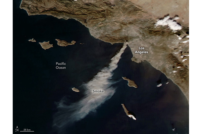
NASAs Aqua satellite captured this view of the Palisades Fire blazing on the afternoon of the day it erupted, Jan. 7, 2025. (Credit: NASA Earth Observatory)NewsletterSign up for our email newsletter for the latest science newsThe headline in the L.A. Times says it all: 5 dead, more than 1,100 structures destroyed as firestorm besieges L.A. County By the time you are reading this, the devastation will almost certainly be worse.Since the Palisades Fire exploded on Tuesday, Jan. 7, other blazes have blown up, including the Eaton Fire near Pasadena, and the Hurst Fire around Sylmar. As I'm writing this on Wednesday evening, Jan. 8, more than 27,000 acres are burning, according to California's Department of Forestry and Fire Protection, also known as CalFire. That's an area nearly twice as large as Manhattan Island in New York. And much more acreage is going to burn before this is all over.This should come as no surprise. Southern California has seen scant rain for nearly nine months. Combine that with winds howling at 100 miles per hour, and a cataclysmic situation was all but inevitable.The View From SpaceI'll be following this developing story and will offer additional weather and climate context when new information emerges. In the meantime, I thought I would share some dramatic remote sensing imagery of the fires: The GOES-18 satellite captured the animated view above of the Palisades and Eaton fires blazing in the Los Angeles area on Jan. 8, 2025. It combines visible wavelengths of light with infrared, which reveals the heat signatures of the fires. The Palisades Fire as seen by the Sentinel 2A satellite on Jan. 7, 2025. (Credit: Modified Copernicus Sentinel data accessed using EO Browser, processed by Tom Yulsman)I created this simulated 3D vew of the Palisades Fire using imagery acquired by the Sentinel 2A satellite not long after the blaze ignited on Jan. 7. The oblique view looks toward the south, with smoke streaming out over Pacific Palisades and the Pacific. Flames are faintly visible through the smoke in the foreground. Smoke plumes from multiple wildfires blazing in the Los Angeles area are seen in this image acquired by NASA's Aqua satellite on Jan. 8, 2025. (Credit: NASA Worldview)The winds have not relented today. They are blowing huge plumes of smoke to the southwest, way out over the Pacific Ocean, as seen in this image captured by NASA's Aqua satellite. Stay tuned for more.


