• This startup wants to make more climate-friendly metal in the US

    A California-based company called Magrathea just turned on a new electrolyzer that can make magnesium metal from seawater. The technology has the potential to produce the material, which is used in vehicles and defense applications, with net-zero greenhouse-gas emissions.

    Magnesium is an incredibly light metal, and it’s used for parts in cars and planes, as well as in aluminum alloys like those in vehicles. The metal is also used in defense and industrial applications, including the production processes for steel and titanium.

    Today, China dominates production of magnesium, and the most common method generates a lot of the emissions that cause climate change. If Magrathea can scale up its process, it could help provide an alternative source of the metal and clean up industries that rely on it, including automotive manufacturing.

    The star of Magrathea’s process is an electrolyzer, a device that uses electricity to split a material into its constituent elements. Using an electrolyzer in magnesium production isn’t new, but Magrathea’s approach represents an update. “We really modernized it and brought it into the 21st century,” says Alex Grant, Magrathea’s cofounder and CEO.

    The whole process starts with salty water. There are small amounts of magnesium in seawater, as well as in salt lakes and groundwater.If you take that seawater or brine and clean it up, concentrate it, and dry it out, you get a solid magnesium chloride salt.

    Magrathea takes that saltand puts it into the electrolyzer. The device reaches temperatures of about 700 °Cand runs electricity through the molten salt to split the magnesium from the chlorine, forming magnesium metal.

    Typically, running an electrolyzer in this process would require a steady source of electricity. The temperature is generally kept just high enough to maintain the salt in a molten state. Allowing it to cool down too much would allow it to solidify, messing up the process and potentially damaging the equipment. Heating it up more than necessary would just waste energy. 

    Magrathea’s approach builds in flexibility. Basically, the company runs its electrolyzer about 100 °C higher than is necessary to keep the molten salt a liquid. It then uses the extra heat in inventive ways, including to dry out the magnesium salt that eventually goes into the reactor. This preparation can be done intermittently, so the company can take in electricity when it’s cheaper or when more renewables are available, cutting costs and emissions. In addition, the process will make a co-product, called magnesium oxide, that can be used to trap carbon dioxide from the atmosphere, helping to cancel out the remaining carbon pollution.

    The result could be a production process with net-zero emissions, according to an independent life cycle assessment completed in January. While it likely won’t reach this bar at first, the potential is there for a much more climate-friendly process than what’s used in the industry today, Grant says.

    Breaking into magnesium production won’t be simple, says Simon Jowitt, director of the Nevada Bureau of Mines and of the Center for Research in Economic Geology at the University of Nevada, Reno.

    China produces roughly 95% of the global supply as of 2024, according to data from the US Geological Survey. This dominant position means companies there can flood the market with cheap metal, making it difficult for others to compete. “The economics of all this is uncertain,” Jowitt says.

    The US has some trade protections in place, including an anti-dumping duty, but newer players with alternative processes can still face obstacles. US Magnesium, a company based in Utah, was the only company making magnesium in the US in recent years, but it shut down production in 2022 after equipment failures and a history of environmental concerns. 

    Magrathea plans to start building a demonstration plant in Utah in late 2025 or early 2026, which will have a capacity of roughly 1,000 tons per year and should be running in 2027. In February the company announced that it signed an agreement with a major automaker, though it declined to share its name on the record. The automaker pre-purchased material from the demonstration plant and will incorporate it into existing products.

    After the demonstration plant is running, the next step would be to build a commercial plant with a larger capacity of around 50,000 tons annually.
    #this #startup #wants #make #more
    This startup wants to make more climate-friendly metal in the US
    A California-based company called Magrathea just turned on a new electrolyzer that can make magnesium metal from seawater. The technology has the potential to produce the material, which is used in vehicles and defense applications, with net-zero greenhouse-gas emissions. Magnesium is an incredibly light metal, and it’s used for parts in cars and planes, as well as in aluminum alloys like those in vehicles. The metal is also used in defense and industrial applications, including the production processes for steel and titanium. Today, China dominates production of magnesium, and the most common method generates a lot of the emissions that cause climate change. If Magrathea can scale up its process, it could help provide an alternative source of the metal and clean up industries that rely on it, including automotive manufacturing. The star of Magrathea’s process is an electrolyzer, a device that uses electricity to split a material into its constituent elements. Using an electrolyzer in magnesium production isn’t new, but Magrathea’s approach represents an update. “We really modernized it and brought it into the 21st century,” says Alex Grant, Magrathea’s cofounder and CEO. The whole process starts with salty water. There are small amounts of magnesium in seawater, as well as in salt lakes and groundwater.If you take that seawater or brine and clean it up, concentrate it, and dry it out, you get a solid magnesium chloride salt. Magrathea takes that saltand puts it into the electrolyzer. The device reaches temperatures of about 700 °Cand runs electricity through the molten salt to split the magnesium from the chlorine, forming magnesium metal. Typically, running an electrolyzer in this process would require a steady source of electricity. The temperature is generally kept just high enough to maintain the salt in a molten state. Allowing it to cool down too much would allow it to solidify, messing up the process and potentially damaging the equipment. Heating it up more than necessary would just waste energy.  Magrathea’s approach builds in flexibility. Basically, the company runs its electrolyzer about 100 °C higher than is necessary to keep the molten salt a liquid. It then uses the extra heat in inventive ways, including to dry out the magnesium salt that eventually goes into the reactor. This preparation can be done intermittently, so the company can take in electricity when it’s cheaper or when more renewables are available, cutting costs and emissions. In addition, the process will make a co-product, called magnesium oxide, that can be used to trap carbon dioxide from the atmosphere, helping to cancel out the remaining carbon pollution. The result could be a production process with net-zero emissions, according to an independent life cycle assessment completed in January. While it likely won’t reach this bar at first, the potential is there for a much more climate-friendly process than what’s used in the industry today, Grant says. Breaking into magnesium production won’t be simple, says Simon Jowitt, director of the Nevada Bureau of Mines and of the Center for Research in Economic Geology at the University of Nevada, Reno. China produces roughly 95% of the global supply as of 2024, according to data from the US Geological Survey. This dominant position means companies there can flood the market with cheap metal, making it difficult for others to compete. “The economics of all this is uncertain,” Jowitt says. The US has some trade protections in place, including an anti-dumping duty, but newer players with alternative processes can still face obstacles. US Magnesium, a company based in Utah, was the only company making magnesium in the US in recent years, but it shut down production in 2022 after equipment failures and a history of environmental concerns.  Magrathea plans to start building a demonstration plant in Utah in late 2025 or early 2026, which will have a capacity of roughly 1,000 tons per year and should be running in 2027. In February the company announced that it signed an agreement with a major automaker, though it declined to share its name on the record. The automaker pre-purchased material from the demonstration plant and will incorporate it into existing products. After the demonstration plant is running, the next step would be to build a commercial plant with a larger capacity of around 50,000 tons annually. #this #startup #wants #make #more
    This startup wants to make more climate-friendly metal in the US
    www.technologyreview.com
    A California-based company called Magrathea just turned on a new electrolyzer that can make magnesium metal from seawater. The technology has the potential to produce the material, which is used in vehicles and defense applications, with net-zero greenhouse-gas emissions. Magnesium is an incredibly light metal, and it’s used for parts in cars and planes, as well as in aluminum alloys like those in vehicles. The metal is also used in defense and industrial applications, including the production processes for steel and titanium. Today, China dominates production of magnesium, and the most common method generates a lot of the emissions that cause climate change. If Magrathea can scale up its process, it could help provide an alternative source of the metal and clean up industries that rely on it, including automotive manufacturing. The star of Magrathea’s process is an electrolyzer, a device that uses electricity to split a material into its constituent elements. Using an electrolyzer in magnesium production isn’t new, but Magrathea’s approach represents an update. “We really modernized it and brought it into the 21st century,” says Alex Grant, Magrathea’s cofounder and CEO. The whole process starts with salty water. There are small amounts of magnesium in seawater, as well as in salt lakes and groundwater. (In seawater, the concentration is about 1,300 parts per million, so magnesium makes up about 0.1% of seawater by weight.) If you take that seawater or brine and clean it up, concentrate it, and dry it out, you get a solid magnesium chloride salt. Magrathea takes that salt (which it currently buys from Cargill) and puts it into the electrolyzer. The device reaches temperatures of about 700 °C (almost 1,300 °F) and runs electricity through the molten salt to split the magnesium from the chlorine, forming magnesium metal. Typically, running an electrolyzer in this process would require a steady source of electricity. The temperature is generally kept just high enough to maintain the salt in a molten state. Allowing it to cool down too much would allow it to solidify, messing up the process and potentially damaging the equipment. Heating it up more than necessary would just waste energy.  Magrathea’s approach builds in flexibility. Basically, the company runs its electrolyzer about 100 °C higher than is necessary to keep the molten salt a liquid. It then uses the extra heat in inventive ways, including to dry out the magnesium salt that eventually goes into the reactor. This preparation can be done intermittently, so the company can take in electricity when it’s cheaper or when more renewables are available, cutting costs and emissions. In addition, the process will make a co-product, called magnesium oxide, that can be used to trap carbon dioxide from the atmosphere, helping to cancel out the remaining carbon pollution. The result could be a production process with net-zero emissions, according to an independent life cycle assessment completed in January. While it likely won’t reach this bar at first, the potential is there for a much more climate-friendly process than what’s used in the industry today, Grant says. Breaking into magnesium production won’t be simple, says Simon Jowitt, director of the Nevada Bureau of Mines and of the Center for Research in Economic Geology at the University of Nevada, Reno. China produces roughly 95% of the global supply as of 2024, according to data from the US Geological Survey. This dominant position means companies there can flood the market with cheap metal, making it difficult for others to compete. “The economics of all this is uncertain,” Jowitt says. The US has some trade protections in place, including an anti-dumping duty, but newer players with alternative processes can still face obstacles. US Magnesium, a company based in Utah, was the only company making magnesium in the US in recent years, but it shut down production in 2022 after equipment failures and a history of environmental concerns.  Magrathea plans to start building a demonstration plant in Utah in late 2025 or early 2026, which will have a capacity of roughly 1,000 tons per year and should be running in 2027. In February the company announced that it signed an agreement with a major automaker, though it declined to share its name on the record. The automaker pre-purchased material from the demonstration plant and will incorporate it into existing products. After the demonstration plant is running, the next step would be to build a commercial plant with a larger capacity of around 50,000 tons annually.
    0 Kommentare ·0 Geteilt ·0 Bewertungen
  • What Causes Glaciers to Collapse like the Event That Buried a Swiss Village?

    May 30, 20253 min readWhat Causes Glaciers to Collapse like the Event That Buried a Swiss Village?Climate change and thawing permafrost play a role in destabilizing glaciersBy Jen Schwartz edited by Dean VisserThe small village of Blatten in the Swiss Alps was largely destroyed by a landslide that occurred as a result of the partial collapse of the Birch Glacier on May 28, 2025. Alexandre Agrusti/AFP via Getty ImagesAn unstable glacier in the Swiss Alps collapsed this week, sending a deluge of rock, ice and mud through the valley below and burying the village of Blatten almost entirely. Scientists had warned about the possibility of a dangerous event related to the glacier, and village residents had been evacuated days earlier—but the glacier’s near-total breakup came as a surprise. One person is reported missing. Government officials initially estimated the debris deposit to be several dozen meters thick and approximately two kilometers long. Making matters worse, the collapse of the glacier, called the Birch Glacier, blocked the flow of the Lonza River, which runs through the valley. As a result, a newly created lake upstream from the debris field flooded an area that has now overflowed into the deposit zone, which could cause a debris flow downstream. As of Friday afternoon local time, officials have reported that the water flow is approaching the top of the scree cone, which is the accumulation of loose, rocky debris.Why did the glacier break apart?The glacier’s collapse and the subsequent landslide—which was so intense that it corresponded to a magnitude 3.1 earthquake captured by the Swiss Seismological Service—likely arose from a series of rockfalls that occurred above the glacier over the past couple of weeks. The rocks, dislodged because of high-altitude snowmelt, exerted significant pressure on the relatively small glacier, according to officials. Experts are looking into longer-term factors that may have weakened the glacier’s stability even before those rockfalls. Christophe Lambiel, a glaciologist who also specializes in high-mountain geology at the University of Lausanne in Switzerland, said on RTS Swiss Television that the rockfalls were linked to climate change. “The increase in the falling rocks is due to the melting permafrost, which increases instability,” Lambiel said, as reported on NPR.On supporting science journalismIf you're enjoying this article, consider supporting our award-winning journalism by subscribing. By purchasing a subscription you are helping to ensure the future of impactful stories about the discoveries and ideas shaping our world today.How would climate change lead to a glacier’s collapse?New research published on Thursday in Science finds that, under current climate policies, more than three quarters of the world’s glacial mass could disappear by the end of this century. In this scenario, almost all small and relatively low-elevation glaciers, like the one in Switzerland, would be wiped out. In a 2024 article for Scientific American, journalist Alec Luhn explained that “the deterioration of ice and snow is triggering feedback loops that will heat the world even further. Permafrost, the frozen ground that holds twice as much carbon as is currently found in the atmosphere, is thawing and releasing these stores.” Thawing permafrost is not just dangerous because it creates instability, as in the case of Birch Glacier. As Luhn wrote, “Research has revealed that the permafrost zone is now releasing more carbon than it absorbs, heating the planet further.”Who is at risk from disintegrating glaciers?It’s clear that the weakening of Switzerland’s Birch Glacier was at least partially caused by rockfall. There are other ways in which changes to glaciers are causing risk—and occasional devastation—to people, communities and infrastructure. As a 2023 E&E News article explained, “At least 15 million people worldwide live in the flood paths of dangerous glacial lakes that can abruptly burst their banks and rush down mountainsides.” These so-called glacial lake outburst floods can be fatal and cause catastrophic damage. “The deterioration of the planet’s snow and ice regions,” wrote Luhn in his 2024 article, “is costing the world billions of dollars in damages,” according to a 2024 State of the Cryosphere report What can be done to preserve glaciers—and protect communities?Giant plastic blankets, gravity snow guns and painted rocks are all potential strategies to slow ice melt in the world’s mountain regions. The sound that glaciers make when water is coursing through their icy cracks can be used to predict glacial lake outburst floods—and thus to save lives. There’s also a growing sense of reckoning with the fate of the world’s glaciers. An essay about the Global Glacier Casualty List, which documents glaciers that have melted or are critically endangered, was also released on Thursday in Science. In it, Rice University anthropologists Cymene Howe and Dominic Boyer write, “The world’s first funeral for a glacier was held in Iceland in 2019 for a little glacier called ‘Ok….’ Since then, memorials for disappeared glaciers have increased across the world, illustrating the integral connection between loss in the natural world and human rituals of remembrance.”
    #what #causes #glaciers #collapse #like
    What Causes Glaciers to Collapse like the Event That Buried a Swiss Village?
    May 30, 20253 min readWhat Causes Glaciers to Collapse like the Event That Buried a Swiss Village?Climate change and thawing permafrost play a role in destabilizing glaciersBy Jen Schwartz edited by Dean VisserThe small village of Blatten in the Swiss Alps was largely destroyed by a landslide that occurred as a result of the partial collapse of the Birch Glacier on May 28, 2025. Alexandre Agrusti/AFP via Getty ImagesAn unstable glacier in the Swiss Alps collapsed this week, sending a deluge of rock, ice and mud through the valley below and burying the village of Blatten almost entirely. Scientists had warned about the possibility of a dangerous event related to the glacier, and village residents had been evacuated days earlier—but the glacier’s near-total breakup came as a surprise. One person is reported missing. Government officials initially estimated the debris deposit to be several dozen meters thick and approximately two kilometers long. Making matters worse, the collapse of the glacier, called the Birch Glacier, blocked the flow of the Lonza River, which runs through the valley. As a result, a newly created lake upstream from the debris field flooded an area that has now overflowed into the deposit zone, which could cause a debris flow downstream. As of Friday afternoon local time, officials have reported that the water flow is approaching the top of the scree cone, which is the accumulation of loose, rocky debris.Why did the glacier break apart?The glacier’s collapse and the subsequent landslide—which was so intense that it corresponded to a magnitude 3.1 earthquake captured by the Swiss Seismological Service—likely arose from a series of rockfalls that occurred above the glacier over the past couple of weeks. The rocks, dislodged because of high-altitude snowmelt, exerted significant pressure on the relatively small glacier, according to officials. Experts are looking into longer-term factors that may have weakened the glacier’s stability even before those rockfalls. Christophe Lambiel, a glaciologist who also specializes in high-mountain geology at the University of Lausanne in Switzerland, said on RTS Swiss Television that the rockfalls were linked to climate change. “The increase in the falling rocks is due to the melting permafrost, which increases instability,” Lambiel said, as reported on NPR.On supporting science journalismIf you're enjoying this article, consider supporting our award-winning journalism by subscribing. By purchasing a subscription you are helping to ensure the future of impactful stories about the discoveries and ideas shaping our world today.How would climate change lead to a glacier’s collapse?New research published on Thursday in Science finds that, under current climate policies, more than three quarters of the world’s glacial mass could disappear by the end of this century. In this scenario, almost all small and relatively low-elevation glaciers, like the one in Switzerland, would be wiped out. In a 2024 article for Scientific American, journalist Alec Luhn explained that “the deterioration of ice and snow is triggering feedback loops that will heat the world even further. Permafrost, the frozen ground that holds twice as much carbon as is currently found in the atmosphere, is thawing and releasing these stores.” Thawing permafrost is not just dangerous because it creates instability, as in the case of Birch Glacier. As Luhn wrote, “Research has revealed that the permafrost zone is now releasing more carbon than it absorbs, heating the planet further.”Who is at risk from disintegrating glaciers?It’s clear that the weakening of Switzerland’s Birch Glacier was at least partially caused by rockfall. There are other ways in which changes to glaciers are causing risk—and occasional devastation—to people, communities and infrastructure. As a 2023 E&E News article explained, “At least 15 million people worldwide live in the flood paths of dangerous glacial lakes that can abruptly burst their banks and rush down mountainsides.” These so-called glacial lake outburst floods can be fatal and cause catastrophic damage. “The deterioration of the planet’s snow and ice regions,” wrote Luhn in his 2024 article, “is costing the world billions of dollars in damages,” according to a 2024 State of the Cryosphere report What can be done to preserve glaciers—and protect communities?Giant plastic blankets, gravity snow guns and painted rocks are all potential strategies to slow ice melt in the world’s mountain regions. The sound that glaciers make when water is coursing through their icy cracks can be used to predict glacial lake outburst floods—and thus to save lives. There’s also a growing sense of reckoning with the fate of the world’s glaciers. An essay about the Global Glacier Casualty List, which documents glaciers that have melted or are critically endangered, was also released on Thursday in Science. In it, Rice University anthropologists Cymene Howe and Dominic Boyer write, “The world’s first funeral for a glacier was held in Iceland in 2019 for a little glacier called ‘Ok….’ Since then, memorials for disappeared glaciers have increased across the world, illustrating the integral connection between loss in the natural world and human rituals of remembrance.” #what #causes #glaciers #collapse #like
    What Causes Glaciers to Collapse like the Event That Buried a Swiss Village?
    www.scientificamerican.com
    May 30, 20253 min readWhat Causes Glaciers to Collapse like the Event That Buried a Swiss Village?Climate change and thawing permafrost play a role in destabilizing glaciersBy Jen Schwartz edited by Dean VisserThe small village of Blatten in the Swiss Alps was largely destroyed by a landslide that occurred as a result of the partial collapse of the Birch Glacier on May 28, 2025. Alexandre Agrusti/AFP via Getty ImagesAn unstable glacier in the Swiss Alps collapsed this week, sending a deluge of rock, ice and mud through the valley below and burying the village of Blatten almost entirely. Scientists had warned about the possibility of a dangerous event related to the glacier, and village residents had been evacuated days earlier—but the glacier’s near-total breakup came as a surprise. One person is reported missing. Government officials initially estimated the debris deposit to be several dozen meters thick and approximately two kilometers long. Making matters worse, the collapse of the glacier, called the Birch Glacier, blocked the flow of the Lonza River, which runs through the valley. As a result, a newly created lake upstream from the debris field flooded an area that has now overflowed into the deposit zone, which could cause a debris flow downstream. As of Friday afternoon local time, officials have reported that the water flow is approaching the top of the scree cone, which is the accumulation of loose, rocky debris.Why did the glacier break apart?The glacier’s collapse and the subsequent landslide—which was so intense that it corresponded to a magnitude 3.1 earthquake captured by the Swiss Seismological Service—likely arose from a series of rockfalls that occurred above the glacier over the past couple of weeks. The rocks, dislodged because of high-altitude snowmelt, exerted significant pressure on the relatively small glacier, according to officials. Experts are looking into longer-term factors that may have weakened the glacier’s stability even before those rockfalls. Christophe Lambiel, a glaciologist who also specializes in high-mountain geology at the University of Lausanne in Switzerland, said on RTS Swiss Television that the rockfalls were linked to climate change. “The increase in the falling rocks is due to the melting permafrost, which increases instability,” Lambiel said, as reported on NPR.On supporting science journalismIf you're enjoying this article, consider supporting our award-winning journalism by subscribing. By purchasing a subscription you are helping to ensure the future of impactful stories about the discoveries and ideas shaping our world today.How would climate change lead to a glacier’s collapse?New research published on Thursday in Science finds that, under current climate policies, more than three quarters of the world’s glacial mass could disappear by the end of this century. In this scenario, almost all small and relatively low-elevation glaciers, like the one in Switzerland, would be wiped out. In a 2024 article for Scientific American, journalist Alec Luhn explained that “the deterioration of ice and snow is triggering feedback loops that will heat the world even further. Permafrost, the frozen ground that holds twice as much carbon as is currently found in the atmosphere, is thawing and releasing these stores.” Thawing permafrost is not just dangerous because it creates instability, as in the case of Birch Glacier. As Luhn wrote, “Research has revealed that the permafrost zone is now releasing more carbon than it absorbs, heating the planet further.”Who is at risk from disintegrating glaciers?It’s clear that the weakening of Switzerland’s Birch Glacier was at least partially caused by rockfall. There are other ways in which changes to glaciers are causing risk—and occasional devastation—to people, communities and infrastructure. As a 2023 E&E News article explained, “At least 15 million people worldwide live in the flood paths of dangerous glacial lakes that can abruptly burst their banks and rush down mountainsides.” These so-called glacial lake outburst floods can be fatal and cause catastrophic damage. “The deterioration of the planet’s snow and ice regions,” wrote Luhn in his 2024 article, “is costing the world billions of dollars in damages,” according to a 2024 State of the Cryosphere report What can be done to preserve glaciers—and protect communities?Giant plastic blankets, gravity snow guns and painted rocks are all potential strategies to slow ice melt in the world’s mountain regions. The sound that glaciers make when water is coursing through their icy cracks can be used to predict glacial lake outburst floods—and thus to save lives. There’s also a growing sense of reckoning with the fate of the world’s glaciers. An essay about the Global Glacier Casualty List, which documents glaciers that have melted or are critically endangered, was also released on Thursday in Science. In it, Rice University anthropologists Cymene Howe and Dominic Boyer write, “The world’s first funeral for a glacier was held in Iceland in 2019 for a little glacier called ‘Ok….’ Since then, memorials for disappeared glaciers have increased across the world, illustrating the integral connection between loss in the natural world and human rituals of remembrance.”
    0 Kommentare ·0 Geteilt ·0 Bewertungen
  • MSLAN corner / Devolution

    MSLAN corner / DevolutionSave this picture!© Xinxin GuoCoffee Shop•Chengdu, China

    Architects:
    Devolution
    Area
    Area of this architecture project

    Area: 
    80 m²

    Year
    Completion year of this architecture project

    Year: 

    2025

    Photographs

    Photographs:Xinxin Guo

    Lead Architects:

    Jiansong Tang, Qi Wang

    More SpecsLess Specs
    this picture!
    Text description provided by the architects. We designed a teahouse with a courtyard along the sloping lakeside terrain at CPI Luhu. The platform in the courtyard draws inspiration from the small courtyards found in Minnan villages. In the design process, we aimed to keep both the building structure and the courtyard as open and transparent as possible.this picture!this picture!The building materials are mostly selected from old timber and old stone slabs in Fujian, retaining the natural texture and temperature in the hope of creating a simple and comfortable spatial atmosphere.this picture!this picture!To bring tea closer to everyday life, we also recycled tea stems and leaves to create tea residue boards, which are used in tabletops, seating, and other details. This allows the memory of tea aroma to become a tangible part of daily life.this picture!this picture!this picture!There is no complicated tea ceremony here, it is more like a place where you can rest your feet at any time and have a cup of tea at your own pace. Embracing the concept of "sharing tea and wandering", it offers a relaxing and easy-going resting experience.this picture!this picture!The spatial layout emphasizes openness and flow, with large floor-to-ceiling windows that naturally extend the tea garden and lake view into the interior.this picture!this picture!Every corner offers a unique perspective and atmosphere, allowing guests to experience a distinct 'tea time by the lake' every time they are seated.this picture!this picture!this picture!

    Project gallerySee allShow less
    Project locationAddress:Chengdu, ChinaLocation to be used only as a reference. It could indicate city/country but not exact address.About this officeDevolutionOffice•••
    MaterialConcreteMaterials and TagsPublished on May 31, 2025Cite: "MSLAN corner / Devolution" 31 May 2025. ArchDaily. Accessed . < ISSN 0719-8884Save想阅读文章的中文版本吗?崎寻·分茶寻游 / 退化建筑是否
    You've started following your first account!Did you know?You'll now receive updates based on what you follow! Personalize your stream and start following your favorite authors, offices and users.Go to my stream
    #mslan #corner #devolution
    MSLAN corner / Devolution
    MSLAN corner / DevolutionSave this picture!© Xinxin GuoCoffee Shop•Chengdu, China Architects: Devolution Area Area of this architecture project Area:  80 m² Year Completion year of this architecture project Year:  2025 Photographs Photographs:Xinxin Guo Lead Architects: Jiansong Tang, Qi Wang More SpecsLess Specs this picture! Text description provided by the architects. We designed a teahouse with a courtyard along the sloping lakeside terrain at CPI Luhu. The platform in the courtyard draws inspiration from the small courtyards found in Minnan villages. In the design process, we aimed to keep both the building structure and the courtyard as open and transparent as possible.this picture!this picture!The building materials are mostly selected from old timber and old stone slabs in Fujian, retaining the natural texture and temperature in the hope of creating a simple and comfortable spatial atmosphere.this picture!this picture!To bring tea closer to everyday life, we also recycled tea stems and leaves to create tea residue boards, which are used in tabletops, seating, and other details. This allows the memory of tea aroma to become a tangible part of daily life.this picture!this picture!this picture!There is no complicated tea ceremony here, it is more like a place where you can rest your feet at any time and have a cup of tea at your own pace. Embracing the concept of "sharing tea and wandering", it offers a relaxing and easy-going resting experience.this picture!this picture!The spatial layout emphasizes openness and flow, with large floor-to-ceiling windows that naturally extend the tea garden and lake view into the interior.this picture!this picture!Every corner offers a unique perspective and atmosphere, allowing guests to experience a distinct 'tea time by the lake' every time they are seated.this picture!this picture!this picture! Project gallerySee allShow less Project locationAddress:Chengdu, ChinaLocation to be used only as a reference. It could indicate city/country but not exact address.About this officeDevolutionOffice••• MaterialConcreteMaterials and TagsPublished on May 31, 2025Cite: "MSLAN corner / Devolution" 31 May 2025. ArchDaily. Accessed . < ISSN 0719-8884Save想阅读文章的中文版本吗?崎寻·分茶寻游 / 退化建筑是否 You've started following your first account!Did you know?You'll now receive updates based on what you follow! Personalize your stream and start following your favorite authors, offices and users.Go to my stream #mslan #corner #devolution
    MSLAN corner / Devolution
    www.archdaily.com
    MSLAN corner / DevolutionSave this picture!© Xinxin GuoCoffee Shop•Chengdu, China Architects: Devolution Area Area of this architecture project Area:  80 m² Year Completion year of this architecture project Year:  2025 Photographs Photographs:Xinxin Guo Lead Architects: Jiansong Tang, Qi Wang More SpecsLess Specs Save this picture! Text description provided by the architects. We designed a teahouse with a courtyard along the sloping lakeside terrain at CPI Luhu. The platform in the courtyard draws inspiration from the small courtyards found in Minnan villages. In the design process, we aimed to keep both the building structure and the courtyard as open and transparent as possible.Save this picture!Save this picture!The building materials are mostly selected from old timber and old stone slabs in Fujian, retaining the natural texture and temperature in the hope of creating a simple and comfortable spatial atmosphere.Save this picture!Save this picture!To bring tea closer to everyday life, we also recycled tea stems and leaves to create tea residue boards, which are used in tabletops, seating, and other details. This allows the memory of tea aroma to become a tangible part of daily life.Save this picture!Save this picture!Save this picture!There is no complicated tea ceremony here, it is more like a place where you can rest your feet at any time and have a cup of tea at your own pace. Embracing the concept of "sharing tea and wandering", it offers a relaxing and easy-going resting experience.Save this picture!Save this picture!The spatial layout emphasizes openness and flow, with large floor-to-ceiling windows that naturally extend the tea garden and lake view into the interior.Save this picture!Save this picture!Every corner offers a unique perspective and atmosphere, allowing guests to experience a distinct 'tea time by the lake' every time they are seated.Save this picture!Save this picture!Save this picture! Project gallerySee allShow less Project locationAddress:Chengdu, ChinaLocation to be used only as a reference. It could indicate city/country but not exact address.About this officeDevolutionOffice••• MaterialConcreteMaterials and TagsPublished on May 31, 2025Cite: "MSLAN corner / Devolution" 31 May 2025. ArchDaily. Accessed . <https://www.archdaily.com/1030433/mslan-corner-devolution&gt ISSN 0719-8884Save想阅读文章的中文版本吗?崎寻·分茶寻游 / 退化建筑是否 You've started following your first account!Did you know?You'll now receive updates based on what you follow! Personalize your stream and start following your favorite authors, offices and users.Go to my stream
    0 Kommentare ·0 Geteilt ·0 Bewertungen
  • I spent 8 years living in big cities on the East Coast before realizing my ideal home was the smaller one where I grew up

    I spent years living in major East Coast cities, and now I'm back in my hometown of Rochester, New York.

    Emma Guillen

    2025-05-30T13:49:39Z

    d

    Read in app

    This story is available exclusively to Business Insider
    subscribers. Become an Insider
    and start reading now.
    Have an account?

    After living in Miami, Boston, and NYC, my husband and I chose to buy a home in Rochester, New York.
    For a midsize city, we think the access to nature and fabulous food is unparalleled.
    We also love the variety of art and culture available through museums and festivals.

    Within 24 hours of graduating from college, I hit the road and drove 1,500 miles away from my hometown to begin my first full-time job. I was officially in the "real world."For the next eight years, I moved from apartment to apartment and city to city, spending my 20s exploring Miami's vibrant art scene, Boston's rich history, and New York City's — well, everything.Still, when it came time to sign another yearlong lease on the Upper East Side of Manhattan, my husband and I reconsidered.With dreams to start a family and possibly a business someday, we decided to move back to my hometown of Rochester, New York, in June 2024.Upstate New York has so much to offer

    I love the festivals, restaurants, museums, and nature in Rochester.

    Emma Guillen

    For a midsize city, I think Rochester has earned some major bragging rights. It's the birthplace of Wegmans, has more than 140 annual festivals, and is home to the largest variety of lilacs on earth.The area's greatness is catching on, too. This year, Redfin named Fairport, a suburb of Rochester, one of the hottest neighborhoods in the country.The food and beverage scene is incredible

    We enjoy the burgers, fries, and drinks at Good Luck.

    Emma Guillen

    I may have been spoiled by New York City's global cuisine, but it's safe to say that Rochester has impressed me, too.If I'm in the mood to go out, I like to make reservations at the upscale steakhouse Patron Saint, the buzzy farm-to-table space Good Luck, or the seven-time Michelin-starred restaurant Redd.Or if the day calls for casual eats, you'll find my husband and me at the beloved hot dog joint Dogtown, the family-owned Mexican eatery Peach Blossom, or a local favorite, Pizza Wizard, for a Detroit-style slice.Award-winning wineries, breweries, and distilleries are also rising in popularity everywhere from Rochester's downtown to suburbs such as Fairport.The beautiful nature is next-level

    My husband and I visited Seneca Lake, one of the 11 Finger Lakes.

    Emma Guillen

    We traded taxis and turnstiles for scenic trails, and we couldn't be happier. With more than 12,000 acres of parkland, this part of New York has plenty of wide open spaces to explore, all a relatively short drive from Rochester's city limits.Our favorite place to hike is Highland Park, which was designed by the same landscape architect who created Central Park.Though we enjoyed our days biking alongside the Hudson River and relaxing on the esplanade in Boston's Back Bay, our proximity to the Finger Lakes is yet another reason we chose to grow roots in Rochester. We love spending weekends in the summer visiting the numerous vineyards in New York's wine country.Living in Rochester also means we can plan a mountain escape to the Adirondacks, a day trip to Niagara Falls, or a last-minute attempt to see the northern lights over Lake Ontario.
    There's always a museum to visit or an event to attend

    I loved visiting George Eastman House.

    Emma Guillen

    We may not be catching Broadway shows on Tuesday nights anymore, but the variety of art and culture here in Rochester is off the charts.I recommend visiting the Strong National Museum of Play, George Eastman House, and the world-class performances at the Rochester International Jazz Festival.My favorite event of the year is Fairport Canal Days, a weekend-long celebration featuring local artisans, trendy food trucks, and a whimsical rubber duck charity race held on the Erie Canal.I'm so glad I found my way back to my hometownIt's officially been a year since I reclaimed my 585 area code, and I haven't regretted it for a second. Although I gave up the hustle and bustle of New York City, the access to nature and family friendly activities have made this move more than worthwhile. Rochester is no longer just my hometown — it's now my forever home.
    #spent #years #living #big #cities
    I spent 8 years living in big cities on the East Coast before realizing my ideal home was the smaller one where I grew up
    I spent years living in major East Coast cities, and now I'm back in my hometown of Rochester, New York. Emma Guillen 2025-05-30T13:49:39Z d Read in app This story is available exclusively to Business Insider subscribers. Become an Insider and start reading now. Have an account? After living in Miami, Boston, and NYC, my husband and I chose to buy a home in Rochester, New York. For a midsize city, we think the access to nature and fabulous food is unparalleled. We also love the variety of art and culture available through museums and festivals. Within 24 hours of graduating from college, I hit the road and drove 1,500 miles away from my hometown to begin my first full-time job. I was officially in the "real world."For the next eight years, I moved from apartment to apartment and city to city, spending my 20s exploring Miami's vibrant art scene, Boston's rich history, and New York City's — well, everything.Still, when it came time to sign another yearlong lease on the Upper East Side of Manhattan, my husband and I reconsidered.With dreams to start a family and possibly a business someday, we decided to move back to my hometown of Rochester, New York, in June 2024.Upstate New York has so much to offer I love the festivals, restaurants, museums, and nature in Rochester. Emma Guillen For a midsize city, I think Rochester has earned some major bragging rights. It's the birthplace of Wegmans, has more than 140 annual festivals, and is home to the largest variety of lilacs on earth.The area's greatness is catching on, too. This year, Redfin named Fairport, a suburb of Rochester, one of the hottest neighborhoods in the country.The food and beverage scene is incredible We enjoy the burgers, fries, and drinks at Good Luck. Emma Guillen I may have been spoiled by New York City's global cuisine, but it's safe to say that Rochester has impressed me, too.If I'm in the mood to go out, I like to make reservations at the upscale steakhouse Patron Saint, the buzzy farm-to-table space Good Luck, or the seven-time Michelin-starred restaurant Redd.Or if the day calls for casual eats, you'll find my husband and me at the beloved hot dog joint Dogtown, the family-owned Mexican eatery Peach Blossom, or a local favorite, Pizza Wizard, for a Detroit-style slice.Award-winning wineries, breweries, and distilleries are also rising in popularity everywhere from Rochester's downtown to suburbs such as Fairport.The beautiful nature is next-level My husband and I visited Seneca Lake, one of the 11 Finger Lakes. Emma Guillen We traded taxis and turnstiles for scenic trails, and we couldn't be happier. With more than 12,000 acres of parkland, this part of New York has plenty of wide open spaces to explore, all a relatively short drive from Rochester's city limits.Our favorite place to hike is Highland Park, which was designed by the same landscape architect who created Central Park.Though we enjoyed our days biking alongside the Hudson River and relaxing on the esplanade in Boston's Back Bay, our proximity to the Finger Lakes is yet another reason we chose to grow roots in Rochester. We love spending weekends in the summer visiting the numerous vineyards in New York's wine country.Living in Rochester also means we can plan a mountain escape to the Adirondacks, a day trip to Niagara Falls, or a last-minute attempt to see the northern lights over Lake Ontario. There's always a museum to visit or an event to attend I loved visiting George Eastman House. Emma Guillen We may not be catching Broadway shows on Tuesday nights anymore, but the variety of art and culture here in Rochester is off the charts.I recommend visiting the Strong National Museum of Play, George Eastman House, and the world-class performances at the Rochester International Jazz Festival.My favorite event of the year is Fairport Canal Days, a weekend-long celebration featuring local artisans, trendy food trucks, and a whimsical rubber duck charity race held on the Erie Canal.I'm so glad I found my way back to my hometownIt's officially been a year since I reclaimed my 585 area code, and I haven't regretted it for a second. Although I gave up the hustle and bustle of New York City, the access to nature and family friendly activities have made this move more than worthwhile. Rochester is no longer just my hometown — it's now my forever home. #spent #years #living #big #cities
    I spent 8 years living in big cities on the East Coast before realizing my ideal home was the smaller one where I grew up
    www.businessinsider.com
    I spent years living in major East Coast cities, and now I'm back in my hometown of Rochester, New York. Emma Guillen 2025-05-30T13:49:39Z Save Saved Read in app This story is available exclusively to Business Insider subscribers. Become an Insider and start reading now. Have an account? After living in Miami, Boston, and NYC, my husband and I chose to buy a home in Rochester, New York. For a midsize city, we think the access to nature and fabulous food is unparalleled. We also love the variety of art and culture available through museums and festivals. Within 24 hours of graduating from college, I hit the road and drove 1,500 miles away from my hometown to begin my first full-time job. I was officially in the "real world."For the next eight years, I moved from apartment to apartment and city to city, spending my 20s exploring Miami's vibrant art scene, Boston's rich history, and New York City's — well, everything.Still, when it came time to sign another yearlong lease on the Upper East Side of Manhattan, my husband and I reconsidered.With dreams to start a family and possibly a business someday, we decided to move back to my hometown of Rochester, New York, in June 2024.Upstate New York has so much to offer I love the festivals, restaurants, museums, and nature in Rochester. Emma Guillen For a midsize city, I think Rochester has earned some major bragging rights. It's the birthplace of Wegmans, has more than 140 annual festivals, and is home to the largest variety of lilacs on earth (a fun fact that requires its own festival, of course).The area's greatness is catching on, too. This year, Redfin named Fairport, a suburb of Rochester, one of the hottest neighborhoods in the country.The food and beverage scene is incredible We enjoy the burgers, fries, and drinks at Good Luck. Emma Guillen I may have been spoiled by New York City's global cuisine, but it's safe to say that Rochester has impressed me, too.If I'm in the mood to go out, I like to make reservations at the upscale steakhouse Patron Saint, the buzzy farm-to-table space Good Luck, or the seven-time Michelin-starred restaurant Redd.Or if the day calls for casual eats, you'll find my husband and me at the beloved hot dog joint Dogtown, the family-owned Mexican eatery Peach Blossom, or a local favorite, Pizza Wizard, for a Detroit-style slice.Award-winning wineries, breweries, and distilleries are also rising in popularity everywhere from Rochester's downtown to suburbs such as Fairport.The beautiful nature is next-level My husband and I visited Seneca Lake, one of the 11 Finger Lakes. Emma Guillen We traded taxis and turnstiles for scenic trails, and we couldn't be happier. With more than 12,000 acres of parkland, this part of New York has plenty of wide open spaces to explore, all a relatively short drive from Rochester's city limits.Our favorite place to hike is Highland Park, which was designed by the same landscape architect who created Central Park.Though we enjoyed our days biking alongside the Hudson River and relaxing on the esplanade in Boston's Back Bay, our proximity to the Finger Lakes is yet another reason we chose to grow roots in Rochester. We love spending weekends in the summer visiting the numerous vineyards in New York's wine country.Living in Rochester also means we can plan a mountain escape to the Adirondacks, a day trip to Niagara Falls, or a last-minute attempt to see the northern lights over Lake Ontario. There's always a museum to visit or an event to attend I loved visiting George Eastman House. Emma Guillen We may not be catching Broadway shows on Tuesday nights anymore, but the variety of art and culture here in Rochester is off the charts.I recommend visiting the Strong National Museum of Play, George Eastman House, and the world-class performances at the Rochester International Jazz Festival.My favorite event of the year is Fairport Canal Days, a weekend-long celebration featuring local artisans, trendy food trucks, and a whimsical rubber duck charity race held on the Erie Canal.I'm so glad I found my way back to my hometownIt's officially been a year since I reclaimed my 585 area code, and I haven't regretted it for a second. Although I gave up the hustle and bustle of New York City, the access to nature and family friendly activities have made this move more than worthwhile. Rochester is no longer just my hometown — it's now my forever home.
    0 Kommentare ·0 Geteilt ·0 Bewertungen
  • How Doppler Radar Lets Meteorologists Predict Weather and Save Lives

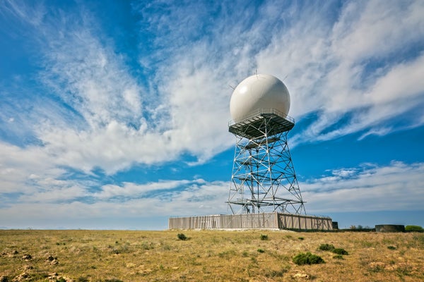
    May 30, 20256 min readInside the Lifesaving Power of Doppler Weather RadarDoppler radar is one of the most revolutionary and lifesaving tools of modern meteorology, which has experts worried about outages because of recent staffing cuts and conspiracy theoriesBy Andrea Thompson edited by Dean Visser Mfotophile/Getty ImagesOutside every National Weather Serviceoffice around the U.S. stands what looks like an enormous white soccer ball, perched atop metal scaffolding several stories high. These somewhat plain spheres look as ho-hum as a town water tower, but tucked inside each is one of modern meteorology’s most revolutionary and lifesaving tools: Doppler radar.The national network of 160 high-resolution radars, installed in 1988 and updated in 2012, sends out microwave pulses that bounce off raindrops or other precipitation to help forecasters see what is falling and how much—providing crucial early information about events ranging from flash floods to blizzards. And the network is especially irreplaceable when it comes to spotting tornadoes; it has substantially lengthened warning times and reduced deaths. Doppler radar has “really revolutionized how we’ve been able to issue warnings,” says Ryan Hanrahan, chief meteorologist of the NBC Connecticut StormTracker team.But now meteorologists and emergency managers are increasingly worried about what might happen if any of these radars go offline, whether because of cuts to the NWS made by the Trump administration or threats from groups that espouse conspiracy theories about the radars being used to control the weather. “Losing radar capabilities would “take us back in time by four decades,” says Jana Houser, a tornado researcher at the Ohio State University. If they go down, “there’s no way we’re going to be effective at storm warnings.”On supporting science journalismIf you're enjoying this article, consider supporting our award-winning journalism by subscribing. By purchasing a subscription you are helping to ensure the future of impactful stories about the discoveries and ideas shaping our world today.How Doppler radars workThe NWS installations form a network called the Next Generation Weather Radar, or NEXRAD. Inside each giant white sphere is a device that looks like a larger version of a home satellite TV dish, with a transmitter that emits pulses in the microwave region of the electromagnetic spectrum. Those pulses bounce off raindrops, snowflakes, hailstones—what meteorologists collectively call hydrometeors—and back to the dish antenna.Amanda MontañezThe power of the returning signals lets experts create a picture of size, shape and intensity of any precipitation—and this is what you see on a phone app’s radar map or a TV broadcast.But NEXRAD can do much, much more than show how hard it’s raining. Within its sphere, each unit rotates and scans up and down through the sky, helping forecasters see what is happening at multiple levels of a storm system. These vertical profiles can show, for example, whether a tornado is forming or a storm is creating a downburst—a rapid downward blast of wind. “Doppler radar basically allows us to see in the clouds,” Hanrahan says.And then there’s the “Doppler” part itself. The name refers to a phenomenon that’s familiar to many, thanks to the electromagnetic waves’ acoustic counterpart. We’ve all experienced this, often most obviously when we hear an emergency vehicle siren pass nearby: the pitch increases as the car gets closer and decreases as it moves away. Similarly, the returning radar bounce from a rain droplet or piece of tornadic debris that is moving toward the emitter will have a shorter wavelength than the pulse that was sent out, and the signal from an object moving away from the radar will have a longer wavelength. This allows the radar to efficiently distinguish the tight circulation of a tornado.These two images show how dual-polarization helps NWS forecasters detect a tornado that is producing damage. The left image shows how the Doppler radar can detect rotation. Between the two yellow arrows, the red color indicates outbound wind, while the green color indicate inbound wind, relative to the location of the radar. The right image shows how dual-polarization information helps detect debris picked up by the tornado.NOAAThe nation’s radar system was upgraded in 2012 to include what is called dual polarization. This means the signal has both vertically and horizontally oriented wavelengths, providing information about precipitation in more than one dimension. “A drizzle droplet is almost perfectly spherical, so it returns the same amount of power in the horizontal and in the vertical,” Hanrahan says, whereas giant drops look almost like “hamburger buns” and so send back more power in the horizontal than the vertical.Are Doppler radars dangerous? Can they affect the weather?Doppler radars do not pose any danger to people, wildlife or structures—and they cannot affect the weather.Along the electromagnetic spectrum, it is the portions with shorter wavelengths such as gamma rays and ultraviolet radiation that can readily damage the human body—because their wavelengths are the right size to interact with and damage DNA or our cells. Doppler radars emit pulses in wavelengths about the size of a baseball.Amanda MontañezBeing hit by extremely concentrated microwave radiation could be harmful; this is why microwave ovens have mesh screens that keep the rays from escaping. Similarly, you wouldn’t want to stand directly in front of a radar microwave beam. Military radar technicians found this out years ago when working on radars under operation, University of California, Los Angeles, climate scientist Daniel Swain said during one of his regular YouTube talks. They “had experiences like the candy bar in their pocket instantly melting and then feeling their skin getting really hot,” he said.Similar to how a microwave oven works, when the microwave signal from a radar hits a hydrometeor, the water molecules vibrate and so generate heat because of friction and reradiate some of the received energy, says Cynthia Fay, who serves as a focal point for the National Weather Service’s Radar Operations Center. But “microwave radiation is really not very powerful, and the whole point is that if you stand more than a couple dozen feet away from the dome it's not even really going to affect your body, let alone the global atmosphere,” Swain adds.At the radar’s antenna, the average power is about 23.5 megawattsof energy, Fay says.But the energy from the radar signal dissipates very rapidly with distance: at just one kilometer from the radar, the power is 0.0000019 MW, and at the radar’s maximum range of 460 kilometers, it is 8.8 x 10⁻¹² MW, Fay says. “Once you’re miles away, it’s just really not a dangerous amount” of energy, Swain said in his video.A supercell thunderstorm that produced an F4 tornado near Meriden, KS, in May 1960, as seen from the WSR-3 radar in Topeka. A supercell thunderstorm that produced an EF5 tornado in Moore, OK, in May 2013, as seen from a modern Doppler weather radar near Oklahoma City.NOAAAnd Doppler radars spend most of their time listening for returns. According to the NWS, for every hour of operation, a radar may spend as little as seven seconds sending out pulses.The idea that Doppler radar can control or affect the weather is “a long-standing conspiracythat has existed really for decades but has kind of accelerated in recent years,” Swain said in his video. It has resurfaced recently with threats to the National Oceanic and Atmospheric Administration radar system from an antigovernment militia group, as first reported by CNN. The Washington Post reported that the group’s founder said that its members were carrying out “attack simulations” on sites in order to later destroy the radars,—which the group believes are “weather weapons,” according to an internal NOAA e-mail. NOAA has advised radar technicians at the NWS’s offices to exercise caution and work in teams when going out to service radars—and to notify local law enforcement of any suspicious activity.“NOAA is aware of recent threats against NEXRAD weather radar sites and is working with local and other authorities in monitoring the situation closely,” wrote a NWS spokesperson in response to a request for comment from Scientific American.What happens if weather radars go offline?NOAA’s radars have been on duty for 24 hours a day, seven days a week and 365 days a year since 1988. “It’s amazing what workhorses these radars have been,” Hanrahan says.The image on the left shows a reflectivity radar image of a supercell thunderstorm that produced several tornadoes on April 19, 2023, near Oklahoma City, OK. The hook shape present often indicates rotation within the storm. The image on the right show velocity information that corresponds to the reflectivity image. Very strong inbound windsare next to very strong outbound winds. This very strong inbound/outbound “couplet” indicates the very strong rotation of a tornado.NOAABut they do require that periodic maintenance because of all the large moving parts needed to operate them. And with Trump administration cuts to NOAA staffing and freezes on some spending, “we just got rid of a lot of the radar maintenance technicians, and we got rid of the budget to repair a lot of these sites,” Swain said in his video. “Most of these are functioning fine right now. The question is: What happens once they go down, once they need a repair?”It is this outage possibility that most worries weather experts, particularly if the breakdowns occur during any kind of severe weather. “Radars are key instruments in issuing tornado warnings,” the Ohio State University’s Houser says. “If a radar goes down, we’re basically down as to what the larger picture is.”And for much of the country—particularly in the West—there is little to no overlap in the areas that each radar covers, meaning other sites would not be able to step in if a neighboring radar is out. Hanrahan says the information provided by the radars is irreplaceable, and the 2012 upgrades mean “we don’t even need to have eyes on a tornado now to know that it’s happening. It’s something that I think we take for granted now.”
    #how #doppler #radar #lets #meteorologists
    How Doppler Radar Lets Meteorologists Predict Weather and Save Lives
    May 30, 20256 min readInside the Lifesaving Power of Doppler Weather RadarDoppler radar is one of the most revolutionary and lifesaving tools of modern meteorology, which has experts worried about outages because of recent staffing cuts and conspiracy theoriesBy Andrea Thompson edited by Dean Visser Mfotophile/Getty ImagesOutside every National Weather Serviceoffice around the U.S. stands what looks like an enormous white soccer ball, perched atop metal scaffolding several stories high. These somewhat plain spheres look as ho-hum as a town water tower, but tucked inside each is one of modern meteorology’s most revolutionary and lifesaving tools: Doppler radar.The national network of 160 high-resolution radars, installed in 1988 and updated in 2012, sends out microwave pulses that bounce off raindrops or other precipitation to help forecasters see what is falling and how much—providing crucial early information about events ranging from flash floods to blizzards. And the network is especially irreplaceable when it comes to spotting tornadoes; it has substantially lengthened warning times and reduced deaths. Doppler radar has “really revolutionized how we’ve been able to issue warnings,” says Ryan Hanrahan, chief meteorologist of the NBC Connecticut StormTracker team.But now meteorologists and emergency managers are increasingly worried about what might happen if any of these radars go offline, whether because of cuts to the NWS made by the Trump administration or threats from groups that espouse conspiracy theories about the radars being used to control the weather. “Losing radar capabilities would “take us back in time by four decades,” says Jana Houser, a tornado researcher at the Ohio State University. If they go down, “there’s no way we’re going to be effective at storm warnings.”On supporting science journalismIf you're enjoying this article, consider supporting our award-winning journalism by subscribing. By purchasing a subscription you are helping to ensure the future of impactful stories about the discoveries and ideas shaping our world today.How Doppler radars workThe NWS installations form a network called the Next Generation Weather Radar, or NEXRAD. Inside each giant white sphere is a device that looks like a larger version of a home satellite TV dish, with a transmitter that emits pulses in the microwave region of the electromagnetic spectrum. Those pulses bounce off raindrops, snowflakes, hailstones—what meteorologists collectively call hydrometeors—and back to the dish antenna.Amanda MontañezThe power of the returning signals lets experts create a picture of size, shape and intensity of any precipitation—and this is what you see on a phone app’s radar map or a TV broadcast.But NEXRAD can do much, much more than show how hard it’s raining. Within its sphere, each unit rotates and scans up and down through the sky, helping forecasters see what is happening at multiple levels of a storm system. These vertical profiles can show, for example, whether a tornado is forming or a storm is creating a downburst—a rapid downward blast of wind. “Doppler radar basically allows us to see in the clouds,” Hanrahan says.And then there’s the “Doppler” part itself. The name refers to a phenomenon that’s familiar to many, thanks to the electromagnetic waves’ acoustic counterpart. We’ve all experienced this, often most obviously when we hear an emergency vehicle siren pass nearby: the pitch increases as the car gets closer and decreases as it moves away. Similarly, the returning radar bounce from a rain droplet or piece of tornadic debris that is moving toward the emitter will have a shorter wavelength than the pulse that was sent out, and the signal from an object moving away from the radar will have a longer wavelength. This allows the radar to efficiently distinguish the tight circulation of a tornado.These two images show how dual-polarization helps NWS forecasters detect a tornado that is producing damage. The left image shows how the Doppler radar can detect rotation. Between the two yellow arrows, the red color indicates outbound wind, while the green color indicate inbound wind, relative to the location of the radar. The right image shows how dual-polarization information helps detect debris picked up by the tornado.NOAAThe nation’s radar system was upgraded in 2012 to include what is called dual polarization. This means the signal has both vertically and horizontally oriented wavelengths, providing information about precipitation in more than one dimension. “A drizzle droplet is almost perfectly spherical, so it returns the same amount of power in the horizontal and in the vertical,” Hanrahan says, whereas giant drops look almost like “hamburger buns” and so send back more power in the horizontal than the vertical.Are Doppler radars dangerous? Can they affect the weather?Doppler radars do not pose any danger to people, wildlife or structures—and they cannot affect the weather.Along the electromagnetic spectrum, it is the portions with shorter wavelengths such as gamma rays and ultraviolet radiation that can readily damage the human body—because their wavelengths are the right size to interact with and damage DNA or our cells. Doppler radars emit pulses in wavelengths about the size of a baseball.Amanda MontañezBeing hit by extremely concentrated microwave radiation could be harmful; this is why microwave ovens have mesh screens that keep the rays from escaping. Similarly, you wouldn’t want to stand directly in front of a radar microwave beam. Military radar technicians found this out years ago when working on radars under operation, University of California, Los Angeles, climate scientist Daniel Swain said during one of his regular YouTube talks. They “had experiences like the candy bar in their pocket instantly melting and then feeling their skin getting really hot,” he said.Similar to how a microwave oven works, when the microwave signal from a radar hits a hydrometeor, the water molecules vibrate and so generate heat because of friction and reradiate some of the received energy, says Cynthia Fay, who serves as a focal point for the National Weather Service’s Radar Operations Center. But “microwave radiation is really not very powerful, and the whole point is that if you stand more than a couple dozen feet away from the dome it's not even really going to affect your body, let alone the global atmosphere,” Swain adds.At the radar’s antenna, the average power is about 23.5 megawattsof energy, Fay says.But the energy from the radar signal dissipates very rapidly with distance: at just one kilometer from the radar, the power is 0.0000019 MW, and at the radar’s maximum range of 460 kilometers, it is 8.8 x 10⁻¹² MW, Fay says. “Once you’re miles away, it’s just really not a dangerous amount” of energy, Swain said in his video.A supercell thunderstorm that produced an F4 tornado near Meriden, KS, in May 1960, as seen from the WSR-3 radar in Topeka. A supercell thunderstorm that produced an EF5 tornado in Moore, OK, in May 2013, as seen from a modern Doppler weather radar near Oklahoma City.NOAAAnd Doppler radars spend most of their time listening for returns. According to the NWS, for every hour of operation, a radar may spend as little as seven seconds sending out pulses.The idea that Doppler radar can control or affect the weather is “a long-standing conspiracythat has existed really for decades but has kind of accelerated in recent years,” Swain said in his video. It has resurfaced recently with threats to the National Oceanic and Atmospheric Administration radar system from an antigovernment militia group, as first reported by CNN. The Washington Post reported that the group’s founder said that its members were carrying out “attack simulations” on sites in order to later destroy the radars,—which the group believes are “weather weapons,” according to an internal NOAA e-mail. NOAA has advised radar technicians at the NWS’s offices to exercise caution and work in teams when going out to service radars—and to notify local law enforcement of any suspicious activity.“NOAA is aware of recent threats against NEXRAD weather radar sites and is working with local and other authorities in monitoring the situation closely,” wrote a NWS spokesperson in response to a request for comment from Scientific American.What happens if weather radars go offline?NOAA’s radars have been on duty for 24 hours a day, seven days a week and 365 days a year since 1988. “It’s amazing what workhorses these radars have been,” Hanrahan says.The image on the left shows a reflectivity radar image of a supercell thunderstorm that produced several tornadoes on April 19, 2023, near Oklahoma City, OK. The hook shape present often indicates rotation within the storm. The image on the right show velocity information that corresponds to the reflectivity image. Very strong inbound windsare next to very strong outbound winds. This very strong inbound/outbound “couplet” indicates the very strong rotation of a tornado.NOAABut they do require that periodic maintenance because of all the large moving parts needed to operate them. And with Trump administration cuts to NOAA staffing and freezes on some spending, “we just got rid of a lot of the radar maintenance technicians, and we got rid of the budget to repair a lot of these sites,” Swain said in his video. “Most of these are functioning fine right now. The question is: What happens once they go down, once they need a repair?”It is this outage possibility that most worries weather experts, particularly if the breakdowns occur during any kind of severe weather. “Radars are key instruments in issuing tornado warnings,” the Ohio State University’s Houser says. “If a radar goes down, we’re basically down as to what the larger picture is.”And for much of the country—particularly in the West—there is little to no overlap in the areas that each radar covers, meaning other sites would not be able to step in if a neighboring radar is out. Hanrahan says the information provided by the radars is irreplaceable, and the 2012 upgrades mean “we don’t even need to have eyes on a tornado now to know that it’s happening. It’s something that I think we take for granted now.” #how #doppler #radar #lets #meteorologists
    How Doppler Radar Lets Meteorologists Predict Weather and Save Lives
    www.scientificamerican.com
    May 30, 20256 min readInside the Lifesaving Power of Doppler Weather RadarDoppler radar is one of the most revolutionary and lifesaving tools of modern meteorology, which has experts worried about outages because of recent staffing cuts and conspiracy theoriesBy Andrea Thompson edited by Dean Visser Mfotophile/Getty ImagesOutside every National Weather Service (NWS) office around the U.S. stands what looks like an enormous white soccer ball, perched atop metal scaffolding several stories high. These somewhat plain spheres look as ho-hum as a town water tower, but tucked inside each is one of modern meteorology’s most revolutionary and lifesaving tools: Doppler radar.The national network of 160 high-resolution radars, installed in 1988 and updated in 2012, sends out microwave pulses that bounce off raindrops or other precipitation to help forecasters see what is falling and how much—providing crucial early information about events ranging from flash floods to blizzards. And the network is especially irreplaceable when it comes to spotting tornadoes; it has substantially lengthened warning times and reduced deaths. Doppler radar has “really revolutionized how we’ve been able to issue warnings,” says Ryan Hanrahan, chief meteorologist of the NBC Connecticut StormTracker team.But now meteorologists and emergency managers are increasingly worried about what might happen if any of these radars go offline, whether because of cuts to the NWS made by the Trump administration or threats from groups that espouse conspiracy theories about the radars being used to control the weather. “Losing radar capabilities would “take us back in time by four decades,” says Jana Houser, a tornado researcher at the Ohio State University. If they go down, “there’s no way we’re going to be effective at storm warnings.”On supporting science journalismIf you're enjoying this article, consider supporting our award-winning journalism by subscribing. By purchasing a subscription you are helping to ensure the future of impactful stories about the discoveries and ideas shaping our world today.How Doppler radars workThe NWS installations form a network called the Next Generation Weather Radar, or NEXRAD. Inside each giant white sphere is a device that looks like a larger version of a home satellite TV dish, with a transmitter that emits pulses in the microwave region of the electromagnetic spectrum. Those pulses bounce off raindrops, snowflakes, hailstones—what meteorologists collectively call hydrometeors—and back to the dish antenna. (The pulses also sometimes bounce off bats, birds and even moving trains, which yield characteristic radar patterns that experts can usually identify.)Amanda MontañezThe power of the returning signals lets experts create a picture of size, shape and intensity of any precipitation—and this is what you see on a phone app’s radar map or a TV broadcast.But NEXRAD can do much, much more than show how hard it’s raining. Within its sphere, each unit rotates and scans up and down through the sky, helping forecasters see what is happening at multiple levels of a storm system. These vertical profiles can show, for example, whether a tornado is forming or a storm is creating a downburst—a rapid downward blast of wind. “Doppler radar basically allows us to see in the clouds,” Hanrahan says.And then there’s the “Doppler” part itself. The name refers to a phenomenon that’s familiar to many, thanks to the electromagnetic waves’ acoustic counterpart. We’ve all experienced this, often most obviously when we hear an emergency vehicle siren pass nearby: the pitch increases as the car gets closer and decreases as it moves away. Similarly, the returning radar bounce from a rain droplet or piece of tornadic debris that is moving toward the emitter will have a shorter wavelength than the pulse that was sent out, and the signal from an object moving away from the radar will have a longer wavelength. This allows the radar to efficiently distinguish the tight circulation of a tornado.These two images show how dual-polarization helps NWS forecasters detect a tornado that is producing damage. The left image shows how the Doppler radar can detect rotation. Between the two yellow arrows, the red color indicates outbound wind, while the green color indicate inbound wind, relative to the location of the radar. The right image shows how dual-polarization information helps detect debris picked up by the tornado.NOAAThe nation’s radar system was upgraded in 2012 to include what is called dual polarization. This means the signal has both vertically and horizontally oriented wavelengths, providing information about precipitation in more than one dimension. “A drizzle droplet is almost perfectly spherical, so it returns the same amount of power in the horizontal and in the vertical,” Hanrahan says, whereas giant drops look almost like “hamburger buns” and so send back more power in the horizontal than the vertical.Are Doppler radars dangerous? Can they affect the weather?Doppler radars do not pose any danger to people, wildlife or structures—and they cannot affect the weather.Along the electromagnetic spectrum, it is the portions with shorter wavelengths such as gamma rays and ultraviolet radiation that can readily damage the human body—because their wavelengths are the right size to interact with and damage DNA or our cells. Doppler radars emit pulses in wavelengths about the size of a baseball.Amanda MontañezBeing hit by extremely concentrated microwave radiation could be harmful; this is why microwave ovens have mesh screens that keep the rays from escaping. Similarly, you wouldn’t want to stand directly in front of a radar microwave beam. Military radar technicians found this out years ago when working on radars under operation, University of California, Los Angeles, climate scientist Daniel Swain said during one of his regular YouTube talks. They “had experiences like the candy bar in their pocket instantly melting and then feeling their skin getting really hot,” he said.Similar to how a microwave oven works, when the microwave signal from a radar hits a hydrometeor, the water molecules vibrate and so generate heat because of friction and reradiate some of the received energy, says Cynthia Fay, who serves as a focal point for the National Weather Service’s Radar Operations Center. But “microwave radiation is really not very powerful, and the whole point is that if you stand more than a couple dozen feet away from the dome it's not even really going to affect your body, let alone the global atmosphere,” Swain adds.At the radar’s antenna, the average power is about 23.5 megawatts (MW) of energy, Fay says. (A weak or moderate thunderstorm may generate about 18 MW in about an hour.) But the energy from the radar signal dissipates very rapidly with distance: at just one kilometer from the radar, the power is 0.0000019 MW, and at the radar’s maximum range of 460 kilometers, it is 8.8 x 10⁻¹² MW, Fay says. “Once you’re miles away, it’s just really not a dangerous amount” of energy, Swain said in his video.A supercell thunderstorm that produced an F4 tornado near Meriden, KS, in May 1960, as seen from the WSR-3 radar in Topeka (left). A supercell thunderstorm that produced an EF5 tornado in Moore, OK, in May 2013, as seen from a modern Doppler weather radar near Oklahoma City (right).NOAAAnd Doppler radars spend most of their time listening for returns. According to the NWS, for every hour of operation, a radar may spend as little as seven seconds sending out pulses.The idea that Doppler radar can control or affect the weather is “a long-standing conspiracy [theory] that has existed really for decades but has kind of accelerated in recent years,” Swain said in his video. It has resurfaced recently with threats to the National Oceanic and Atmospheric Administration radar system from an antigovernment militia group, as first reported by CNN. The Washington Post reported that the group’s founder said that its members were carrying out “attack simulations” on sites in order to later destroy the radars,—which the group believes are “weather weapons,” according to an internal NOAA e-mail. NOAA has advised radar technicians at the NWS’s offices to exercise caution and work in teams when going out to service radars—and to notify local law enforcement of any suspicious activity.“NOAA is aware of recent threats against NEXRAD weather radar sites and is working with local and other authorities in monitoring the situation closely,” wrote a NWS spokesperson in response to a request for comment from Scientific American.What happens if weather radars go offline?NOAA’s radars have been on duty for 24 hours a day, seven days a week and 365 days a year since 1988 (with brief downtimes for maintenance and upgrades). “It’s amazing what workhorses these radars have been,” Hanrahan says.The image on the left shows a reflectivity radar image of a supercell thunderstorm that produced several tornadoes on April 19, 2023, near Oklahoma City, OK. The hook shape present often indicates rotation within the storm. The image on the right show velocity information that corresponds to the reflectivity image. Very strong inbound winds (green colors) are next to very strong outbound winds (bright red/yellow colors). This very strong inbound/outbound “couplet” indicates the very strong rotation of a tornado.NOAABut they do require that periodic maintenance because of all the large moving parts needed to operate them. And with Trump administration cuts to NOAA staffing and freezes on some spending, “we just got rid of a lot of the radar maintenance technicians, and we got rid of the budget to repair a lot of these sites,” Swain said in his video. “Most of these are functioning fine right now. The question is: What happens once they go down, once they need a repair?”It is this outage possibility that most worries weather experts, particularly if the breakdowns occur during any kind of severe weather. “Radars are key instruments in issuing tornado warnings,” the Ohio State University’s Houser says. “If a radar goes down, we’re basically down as to what the larger picture is.”And for much of the country—particularly in the West—there is little to no overlap in the areas that each radar covers, meaning other sites would not be able to step in if a neighboring radar is out. Hanrahan says the information provided by the radars is irreplaceable, and the 2012 upgrades mean “we don’t even need to have eyes on a tornado now to know that it’s happening. It’s something that I think we take for granted now.”
    0 Kommentare ·0 Geteilt ·0 Bewertungen
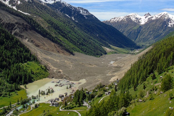
CGShares https://cgshares.com