
99.999 Percent of the Deep Ocean Is Unexplored — Its Secrets Are Key to Understanding Our Planet
From August 23rd - September 14th, 2023, NOAA Ocean Exploration conducted Seascape Alaska 5: Gulf of Alaska Remotely Operated Vehicle Exploration and Mapping, a remotely operated vehicleand mapping expedition to the Gulf of Alaska on NOAA Ship Okeanos Explorer. Operations during this 23-day expedition included the completion of 19 successful remotely operated vehicledives, which were conducted in water depths ranging from 253.1 m to 4261.5 m for approximately 87 hours of bottom time and resulted in the collection of 383 samples. EX2306 also collected more than 28,000 sq. km of seafloor bathymetry and associated water column data using an EM 304 multibeam sonar.
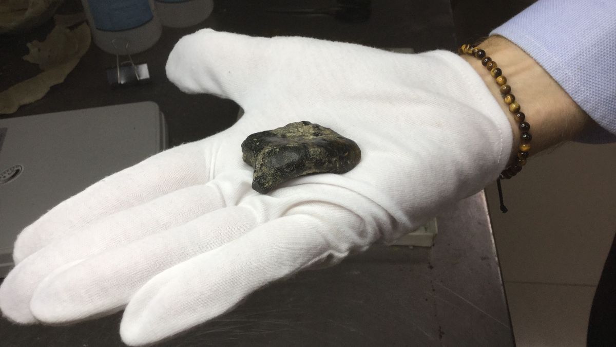
These images were captured on dives that were included in the source data for the How Little We’ve Seen: A Visual Coverage Estimate of the Deep Seafloor paper. They are good general reference imagery for the type of deep ocean observations captured by ROVs.NewsletterSign up for our email newsletter for the latest science newsKey Takeaways on Deep Ocean Exploration: We have visually explored less than 0.001 percent of the deep sea floor. To put that in perspective, 66 percent of the planet is deep ocean, and 99.999 percent of that ocean is unknown to us.Like ecosystems on land, the sea has a complex food web. Most of life in the sea depends on detritus, mostly phytoplankton, falling down from the surface, something called “marine snow.”Organisms that live in shallow water absorb carbon dioxide and take that with them when they sink to the bottom, often to be buried in deep-sea sediment. This is known as a carbon sink. It’s important to know the rates at which this happens, because this partially offsets the carbon we’re adding to the atmosphere. It’s been said many times that we know more about the moon than our own ocean. But is it really true that we’ve explored only a tiny portion of the sea?Katy Croff Bell wondered about this, too. Bell is an oceanographer and the founder of the Ocean Discovery League. She knew that Woods Hole Oceanographic Institution and others have been operating deep-sea submersibles like Alvin for decades, and there are facilities in 20 or so places around the world doing deep-sea research. But how much of the sea floor have these projects actually explored visually, not just mapped or sampled?Mapping the Deep OceanBell started looking up dive data and doing some math. “I stayed up way too late and came up with a very, very tiny number,” she recalls. She didn’t believe her own results and got everyone she could think of to double-check her math. But the results held. Over the next four years, she and her team compiled a database of dives from organizations and individuals around the world, and the data support her initial estimate. The number is indeed tiny. It turns out that we have visually explored less than 0.001 percent of the deep sea floor. To put that in perspective, 66 percent of the planet is deep ocean, and 99.999 percent of that ocean is unknown to us. Bell and her team published their findings in May 2025 in the journal Science Advances.Why Deep Sea Exploration MattersFrom July 14 - July 25, 2023, NOAA Ocean Exploration and partners conducted the third in a series of Seascape Alaska expeditions on NOAA Ship Okeanos Explorer. Over the course of 12 days at sea, the team conducted 6 full remotely operated vehicledives, mapped nearly 16,000 square kilometers, and collected a variety of biological and geological samples. When combined with numerous biological and geological observations, data from the Seascape Alaska 3: Aleutians Remotely Operated Vehicle Exploration and Mapping expedition will help to establish a baseline assessment of the ocean environment, increase understanding of marine life and habitats to inform management decisions, and increase public awareness of ocean issues.
These images were captured on dives that were included in the source data for the How Little We’ve Seen: A Visual Coverage Estimate of the Deep Seafloor paper. They are good general reference imagery for the type of deep ocean observations captured by ROVs.About 26 percent of the ocean has been mapped with multi-beam sonar, explains Bell, and that gives us an idea of the shape of the ocean floor. But that’s like looking at a topographical map of an area you’re planning to hike. You know where the hills and valleys are, but you have no idea what kind of plants and animals you’re likely to encounter. If you want to understand the deep ocean, you need to get down there and see what kind of rocks and sediment are there, learn about the corals and sponges and other animals living there, she says. Samples of ocean life are helpful, but they do not give anything like a full picture of the life-forms in the deep sea, and more importantly, they tell you little about the complex ecosystems they’re a part of. But when you put mapping and sampling together with visual data, plus data about temperature, depths, and salinity, Bell says, you start to build a picture of what a given ocean habitat is like, and eventually, the role of that habitat in the global ocean system.The Deep-Sea "Snow" That Provides LifeFrom August 23rd - September 14th, 2023, NOAA Ocean Exploration conducted Seascape Alaska 5: Gulf of Alaska Remotely Operated Vehicle Exploration and Mapping, a remotely operated vehicleand mapping expedition to the Gulf of Alaska on NOAA Ship Okeanos Explorer. Operations during this 23-day expedition included the completion of 19 successful remotely operated vehicledives, which were conducted in water depths ranging from 253.1 m to 4261.5 m for approximately 87 hours of bottom time and resulted in the collection of 383 samples. EX2306 also collected more than 28,000 sq. km of seafloor bathymetry and associated water column data using an EM 304 multibeam sonar.
These images were captured on dives that were included in the source data for the How Little We’ve Seen: A Visual Coverage Estimate of the Deep Seafloor paper. They are good general reference imagery for the type of deep ocean observations captured by ROVs.Like ecosystems on land, the sea has a complex food web. Most of life in the sea depends on detritus, mostly phytoplankton, falling down from the surface, something called “marine snow,” explains James Douglass, an ecologist at Florida Gulf Coast University who studies life on the sea bed. This snow of nutrients is eaten by what are called suspension feeders, including filter feeders, such as sponges and corals, which have tentacles or basket-like appendages to trap the snow. Then other organisms, such as crabs and worms, feed on these creatures. The crabs and worms, in turn, are eaten by fish. Deposit feeders, such as the sea pig, a type of sea cucumber that “trundles across the bottom eating mud all day,” add to the already huge variety of life, Douglass says. The types of organisms you have in the deep sea depend on how deep it is, whether the sea floor is rocky or muddy, how quickly currents bring food, and whether there are underwater hot springs or cold seeps, or other sources of extra energy, says Douglass. So yes, it’s a complicated world down there, and there’s an awful lot we don’t yet know.Deep-Sea Ecosystems and Climate Change From July 14 - July 25, 2023, NOAA Ocean Exploration and partners conducted the third in a series of Seascape Alaska expeditions on NOAA Ship Okeanos Explorer. Over the course of 12 days at sea, the team conducted 6 full remotely operated vehicledives, mapped nearly 16,000 square kilometers, and collected a variety of biological and geological samples. When combined with numerous biological and geological observations, data from the Seascape Alaska 3: Aleutians Remotely Operated Vehicle Exploration and Mapping expedition will help to establish a baseline assessment of the ocean environment, increase understanding of marine life and habitats to inform management decisions, and increase public awareness of ocean issues.
These images were captured on dives that were included in the source data for the How Little We’ve Seen: A Visual Coverage Estimate of the Deep Seafloor paper. They are good general reference imagery for the type of deep ocean observations captured by ROVs.Learning about ocean ecosystems is extremely valuable as basic science. But it has a more urgent purpose as well. Though we often think of the land and the sea as two completely separate places, they are intertwined in many significant ways. The ocean has absorbed 90 percent of the excess heat and 30 percent of the carbon dioxide released into the atmosphere by humans, says Bell. “But we don’t really have a good understanding of how this is going to impact deep-sea ecosystems, and those ecosystems play a vital role in the process of carbon sequestration,” she says.When it comes to climate change, the deep sea has a lot to teach us. In parts of the deep sea, Douglass explains, nothing disturbs the layers of sediment that are deposited slowly over the course of thousands, even millions of years. Geologists can interpret the layers and study the fossils preserved in them to get an understanding of what the conditions of the planet were like in the distant past, similar to the way climatologists study Antarctic ice cores. “We've learned things about how the ocean ecosystem changes when climate changes. We've learned that some worrying things can happen under certain climate conditions in the deep ocean,” Douglass says. “For example, the ocean can become less oxygenated, which would be a catastrophic threat to deep-sea life.”The Deep Ocean and Climate RegulationAnd, of course, there’s carbon dioxide. “The deep sea is not just a passive record of what happened to the climate; it’s involved in regulating climate,” Douglass says. Organisms that live in shallow water absorb carbon dioxide and take that with them when they sink to the bottom, often to be buried in deep-sea sediment. This is known as a carbon sink. Douglass says it’s very important to know the rates at which this happens, because this partially offsets the carbon we’re adding to the atmosphere. “Deep-sea carbon storage is a huge element in our understanding of the planet's ability to regulate climate,” he adds.If we are to truly understand the way the entire planet works, we need to understand the deep sea and its complex ecosystems as well as life on land and in the shallows. And to do that, Bell says, we need to get down there and look.Article SourcesOur writers at Discovermagazine.com use peer-reviewed studies and high-quality sources for our articles, and our editors review for scientific accuracy and editorial standards. Review the sources used below for this article:Science Advances. How little we’ve seen: A visual coverage estimate of the deep seafloorAvery Hurt is a freelance science journalist. In addition to writing for Discover, she writes regularly for a variety of outlets, both print and online, including National Geographic, Science News Explores, Medscape, and WebMD. She’s the author of Bullet With Your Name on It: What You Will Probably Die From and What You Can Do About It, Clerisy Press 2007, as well as several books for young readers. Avery got her start in journalism while attending university, writing for the school newspaper and editing the student non-fiction magazine. Though she writes about all areas of science, she is particularly interested in neuroscience, the science of consciousness, and AI–interests she developed while earning a degree in philosophy.1 free article leftWant More? Get unlimited access for as low as /monthSubscribeAlready a subscriber?Register or Log In1 free articleSubscribeWant more?Keep reading for as low as !SubscribeAlready a subscriber?Register or Log In
#percent #deep #ocean #unexplored #its
99.999 Percent of the Deep Ocean Is Unexplored — Its Secrets Are Key to Understanding Our Planet
From August 23rd - September 14th, 2023, NOAA Ocean Exploration conducted Seascape Alaska 5: Gulf of Alaska Remotely Operated Vehicle Exploration and Mapping, a remotely operated vehicleand mapping expedition to the Gulf of Alaska on NOAA Ship Okeanos Explorer. Operations during this 23-day expedition included the completion of 19 successful remotely operated vehicledives, which were conducted in water depths ranging from 253.1 m to 4261.5 m for approximately 87 hours of bottom time and resulted in the collection of 383 samples. EX2306 also collected more than 28,000 sq. km of seafloor bathymetry and associated water column data using an EM 304 multibeam sonar.
These images were captured on dives that were included in the source data for the How Little We’ve Seen: A Visual Coverage Estimate of the Deep Seafloor paper. They are good general reference imagery for the type of deep ocean observations captured by ROVs.NewsletterSign up for our email newsletter for the latest science newsKey Takeaways on Deep Ocean Exploration: We have visually explored less than 0.001 percent of the deep sea floor. To put that in perspective, 66 percent of the planet is deep ocean, and 99.999 percent of that ocean is unknown to us.Like ecosystems on land, the sea has a complex food web. Most of life in the sea depends on detritus, mostly phytoplankton, falling down from the surface, something called “marine snow.”Organisms that live in shallow water absorb carbon dioxide and take that with them when they sink to the bottom, often to be buried in deep-sea sediment. This is known as a carbon sink. It’s important to know the rates at which this happens, because this partially offsets the carbon we’re adding to the atmosphere. It’s been said many times that we know more about the moon than our own ocean. But is it really true that we’ve explored only a tiny portion of the sea?Katy Croff Bell wondered about this, too. Bell is an oceanographer and the founder of the Ocean Discovery League. She knew that Woods Hole Oceanographic Institution and others have been operating deep-sea submersibles like Alvin for decades, and there are facilities in 20 or so places around the world doing deep-sea research. But how much of the sea floor have these projects actually explored visually, not just mapped or sampled?Mapping the Deep OceanBell started looking up dive data and doing some math. “I stayed up way too late and came up with a very, very tiny number,” she recalls. She didn’t believe her own results and got everyone she could think of to double-check her math. But the results held. Over the next four years, she and her team compiled a database of dives from organizations and individuals around the world, and the data support her initial estimate. The number is indeed tiny. It turns out that we have visually explored less than 0.001 percent of the deep sea floor. To put that in perspective, 66 percent of the planet is deep ocean, and 99.999 percent of that ocean is unknown to us. Bell and her team published their findings in May 2025 in the journal Science Advances.Why Deep Sea Exploration MattersFrom July 14 - July 25, 2023, NOAA Ocean Exploration and partners conducted the third in a series of Seascape Alaska expeditions on NOAA Ship Okeanos Explorer. Over the course of 12 days at sea, the team conducted 6 full remotely operated vehicledives, mapped nearly 16,000 square kilometers, and collected a variety of biological and geological samples. When combined with numerous biological and geological observations, data from the Seascape Alaska 3: Aleutians Remotely Operated Vehicle Exploration and Mapping expedition will help to establish a baseline assessment of the ocean environment, increase understanding of marine life and habitats to inform management decisions, and increase public awareness of ocean issues.
These images were captured on dives that were included in the source data for the How Little We’ve Seen: A Visual Coverage Estimate of the Deep Seafloor paper. They are good general reference imagery for the type of deep ocean observations captured by ROVs.About 26 percent of the ocean has been mapped with multi-beam sonar, explains Bell, and that gives us an idea of the shape of the ocean floor. But that’s like looking at a topographical map of an area you’re planning to hike. You know where the hills and valleys are, but you have no idea what kind of plants and animals you’re likely to encounter. If you want to understand the deep ocean, you need to get down there and see what kind of rocks and sediment are there, learn about the corals and sponges and other animals living there, she says. Samples of ocean life are helpful, but they do not give anything like a full picture of the life-forms in the deep sea, and more importantly, they tell you little about the complex ecosystems they’re a part of. But when you put mapping and sampling together with visual data, plus data about temperature, depths, and salinity, Bell says, you start to build a picture of what a given ocean habitat is like, and eventually, the role of that habitat in the global ocean system.The Deep-Sea "Snow" That Provides LifeFrom August 23rd - September 14th, 2023, NOAA Ocean Exploration conducted Seascape Alaska 5: Gulf of Alaska Remotely Operated Vehicle Exploration and Mapping, a remotely operated vehicleand mapping expedition to the Gulf of Alaska on NOAA Ship Okeanos Explorer. Operations during this 23-day expedition included the completion of 19 successful remotely operated vehicledives, which were conducted in water depths ranging from 253.1 m to 4261.5 m for approximately 87 hours of bottom time and resulted in the collection of 383 samples. EX2306 also collected more than 28,000 sq. km of seafloor bathymetry and associated water column data using an EM 304 multibeam sonar.
These images were captured on dives that were included in the source data for the How Little We’ve Seen: A Visual Coverage Estimate of the Deep Seafloor paper. They are good general reference imagery for the type of deep ocean observations captured by ROVs.Like ecosystems on land, the sea has a complex food web. Most of life in the sea depends on detritus, mostly phytoplankton, falling down from the surface, something called “marine snow,” explains James Douglass, an ecologist at Florida Gulf Coast University who studies life on the sea bed. This snow of nutrients is eaten by what are called suspension feeders, including filter feeders, such as sponges and corals, which have tentacles or basket-like appendages to trap the snow. Then other organisms, such as crabs and worms, feed on these creatures. The crabs and worms, in turn, are eaten by fish. Deposit feeders, such as the sea pig, a type of sea cucumber that “trundles across the bottom eating mud all day,” add to the already huge variety of life, Douglass says. The types of organisms you have in the deep sea depend on how deep it is, whether the sea floor is rocky or muddy, how quickly currents bring food, and whether there are underwater hot springs or cold seeps, or other sources of extra energy, says Douglass. So yes, it’s a complicated world down there, and there’s an awful lot we don’t yet know.Deep-Sea Ecosystems and Climate Change From July 14 - July 25, 2023, NOAA Ocean Exploration and partners conducted the third in a series of Seascape Alaska expeditions on NOAA Ship Okeanos Explorer. Over the course of 12 days at sea, the team conducted 6 full remotely operated vehicledives, mapped nearly 16,000 square kilometers, and collected a variety of biological and geological samples. When combined with numerous biological and geological observations, data from the Seascape Alaska 3: Aleutians Remotely Operated Vehicle Exploration and Mapping expedition will help to establish a baseline assessment of the ocean environment, increase understanding of marine life and habitats to inform management decisions, and increase public awareness of ocean issues.
These images were captured on dives that were included in the source data for the How Little We’ve Seen: A Visual Coverage Estimate of the Deep Seafloor paper. They are good general reference imagery for the type of deep ocean observations captured by ROVs.Learning about ocean ecosystems is extremely valuable as basic science. But it has a more urgent purpose as well. Though we often think of the land and the sea as two completely separate places, they are intertwined in many significant ways. The ocean has absorbed 90 percent of the excess heat and 30 percent of the carbon dioxide released into the atmosphere by humans, says Bell. “But we don’t really have a good understanding of how this is going to impact deep-sea ecosystems, and those ecosystems play a vital role in the process of carbon sequestration,” she says.When it comes to climate change, the deep sea has a lot to teach us. In parts of the deep sea, Douglass explains, nothing disturbs the layers of sediment that are deposited slowly over the course of thousands, even millions of years. Geologists can interpret the layers and study the fossils preserved in them to get an understanding of what the conditions of the planet were like in the distant past, similar to the way climatologists study Antarctic ice cores. “We've learned things about how the ocean ecosystem changes when climate changes. We've learned that some worrying things can happen under certain climate conditions in the deep ocean,” Douglass says. “For example, the ocean can become less oxygenated, which would be a catastrophic threat to deep-sea life.”The Deep Ocean and Climate RegulationAnd, of course, there’s carbon dioxide. “The deep sea is not just a passive record of what happened to the climate; it’s involved in regulating climate,” Douglass says. Organisms that live in shallow water absorb carbon dioxide and take that with them when they sink to the bottom, often to be buried in deep-sea sediment. This is known as a carbon sink. Douglass says it’s very important to know the rates at which this happens, because this partially offsets the carbon we’re adding to the atmosphere. “Deep-sea carbon storage is a huge element in our understanding of the planet's ability to regulate climate,” he adds.If we are to truly understand the way the entire planet works, we need to understand the deep sea and its complex ecosystems as well as life on land and in the shallows. And to do that, Bell says, we need to get down there and look.Article SourcesOur writers at Discovermagazine.com use peer-reviewed studies and high-quality sources for our articles, and our editors review for scientific accuracy and editorial standards. Review the sources used below for this article:Science Advances. How little we’ve seen: A visual coverage estimate of the deep seafloorAvery Hurt is a freelance science journalist. In addition to writing for Discover, she writes regularly for a variety of outlets, both print and online, including National Geographic, Science News Explores, Medscape, and WebMD. She’s the author of Bullet With Your Name on It: What You Will Probably Die From and What You Can Do About It, Clerisy Press 2007, as well as several books for young readers. Avery got her start in journalism while attending university, writing for the school newspaper and editing the student non-fiction magazine. Though she writes about all areas of science, she is particularly interested in neuroscience, the science of consciousness, and AI–interests she developed while earning a degree in philosophy.1 free article leftWant More? Get unlimited access for as low as /monthSubscribeAlready a subscriber?Register or Log In1 free articleSubscribeWant more?Keep reading for as low as !SubscribeAlready a subscriber?Register or Log In
#percent #deep #ocean #unexplored #its
0 Comentários
·0 Compartilhamentos
·0 Anterior